Caution: Everything you are about to read is probably false. I don’t want to delete this post, but the number you see below just can’t be right. Thanks Rich for pointing what should have been the obvious.
I just received this little tidbit in my inbox a few minutes ago and was mildly surprised.

It says that this year’s Etape du Tour will have 4600 meters of elevation gain, which is the same as climbing Mont Blanc from sea level.
I’ve never done that, but I have done a Ventoux Triple or two and 4600 meters is in the ballpark of that little test of madness, too.
It’s not the biggest amount of climbing the Etape has ever seen (done that), but I just thought it’d be less, given the profile. Maybe the lack of a 3rd peak had me fooled. Anyway, you’ve been warned, riders carrying extra weight this spring. You’ll want to be as slender as a Schleck come July.
This isn’t the profile, but it is the latest detailed map of the route.
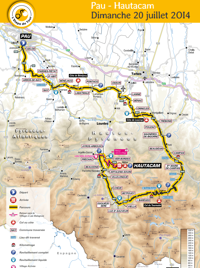

What this route has combined with elevation gain is elements. The temperatures can swing dramatically along this route. Or not. You won’t know until a week ahead, or a day ahead. Out of Pau, it’ll be a massive sprint for position. The small winding roads from Gan to Nay and along the foothills have short punchy climbs. Riders will want to power up that road from Bagneres-de-Bigorre to St-Marie-de-Campan, but there is a lot left in the day. This is a perseverance route with varying speeds and a steep climb up the Hautacam after the legs have cooled on a long descent from the Tourmalet. It’s a challenge from the inside out and a really good route for an Etape. Good luck – so excited for you.
Thanks a lot Gerry. I was specifically avoiding reading that email blast from ASO out of fear of knowing what I am woefully under-prepared for.
I think someone has a major calculation problem. This stage will be one of the lowest climbing stages in recent memory of l’Etape du Tours. It has 75km of rolling terrain and only 2 major climbs, and only 148km. Compare this with 2012 which had 4/5 major climbs and 200km.
From the ASO website – it’ll be around 3000m.
DEUX GÉANTS AU PROGRAMME !
Edito Col du Tourmalet et montée du Hautacam : deux des difficultés emblématiques du massif pyrénéen testeront les concurrents lors de L’Etape du Tour 2014. En cumulé, ce seront plus de 30km à plus de 7% de dénivelé moyen qui attendront le peloton le plus important de l’Hexagone pour un dénivelé positif cumulé de plus de 3 000m.
I knew something was fishy about that! And I suppose I could have fact-checked, but hey, that email was actually from ASO! Is my French messed up that badly, or do you read the same thing as me up there?
Perhaps they just assumed you were the proud possessor of Anglo-Saxon antecedents and automatically translated the figure into feet or megalithic yards (google is your friend) or something…:~}
I really should have thought a few seconds before posting this. Whatever street cred I had has been severely eroded!
Obviously, we still have problems with GPS and satellites and stuff – whether it’s locating a plane or determining the correct altitude of waypoints along a give route. Strava has yet another opinion on the expected evelation gain, and it’s not 3000m, sorry: http://www.strava.com/routes/55191
Weird. It just doesn’t add up to me, though. Adding up the two big climbs would be under 3000 meters, so does that leave 1500+ on the approach to Tourmalet? I hope to hell not!