Or so it seems. Strava, it appears, is not only a playpen for overly-competitive type A’s (although it’s definitely that. The KOM I achieved yesterday has already been bested…I will go back and rectify this!), it is also informative. How?
One of the guys I follow – and one of my future clients for an Alps tour this summer – just climbed what looked like a mistake: an 80 km segment that had 3157 meters of elevation gain…straight up. I had heard rumors of this mythic monster, but hadn’t seen a profile of the beast till yesterday.

This is the graph that profiles the Alto de Letras, Colombia’s (and the world’s?) longest climb. It starts at a (presumably) sub-tropical 468 meters, in the town of Mariquita, and tops out at an arctic 3663 meters.
Take a moment and think about the longest climb you’ve ever done, then start multiplying not only the elevation gain, but the distance as well. For me, I suppose the Col de la Bonette would be one of the longest/highest I’ve done:
- Distance: 24 km
- Elevation gain: 1589
- Highest point: 2802
So for me: Distance x 3.3, Elevation gain x 2, Highest point x 1.3.
Here is a helpful graph with a few other famous climbs that highlights the Alto de Letras’ awesomeness.
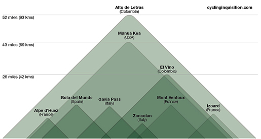
Graph by Cycling Inquisition
So, fellow Strava users, when you get that KOM on the ‘Climb from Stop Sign to 7-11’ segment you created last week, pause for a second and return to reality. You’ll be a better, humbler climber for it.
Read Cycling Inquisition’s article on this climb here (and everything else he writes). Here is a personal account of the climb, too.

Very informative. For some reason I was thinking Mauna Kea was the longest climb in the world (http://app.strava.com/segments/1504789). My longest is Mount Evans (http://app.strava.com/segments/642991), which I believe is the longest in the US.
After reading this, I might be making a trip to Columbia someday.
I wondered briefly how we would determine what a ‘climb’ actually is anyway. Do you have any insight into this? I mean, I could probably find a series of roads that lead from the Bay of Bengal to Tibet, which would be a lot longer and higher than Mauna Kea or this one in Colombia. There must be a rule lying around someplace.
Good question. I would define the beginning of the climb from the first pitch, and would only consider it a climb if it gains a certain amount of elevation (1,000 km maybe?). I seem to remember reading somewhere that there aren’t a lot of road cycling climbs in the high Himalayas because of the condition of paved roads in altitude, but you can probably find some insane mountain biking climbs.
I’ve heard of some big climbs in China, but I doubt we would find Strava segments. Same for Afghanistan, like the Khyber Pass, which is probably not popular among traveling road climbers. 🙂
We’ll probably never know for sure which is the true longest climb, but it’s still fun to talk about.
Hi, I lived in China from 1989-2014 and did many big and long climbs there.
One epic climb that I had been looking at for many years, is one in Sichuan Province, starting from Yingxiuzhen (alt. 880m) and going up to Balangshan (alt. 4525m) in about 112 km.
I finally did this climb in 2012. You can watch the video on Youtube:
I have to agree with you that it is difficult to say what the longest climb really is. For me it has to be an interrupted ascent, which this one was (it followed the river until the switchback started). This climb could have been longer if I had cycled non-stop from Chengdu. But that wasn’t feasible in one day (I rode from Chengdu to Yingxiuzhen the day before).
Maybe the road that takes you from Kathmandu to Tibet would be a good candidate, but I do not know whether it has some downhill sections, as I haven’t done it.
I used to live in Xi’an in Northern China, and in the period 1995-2000 we would sometimes do the ride from Jiaotong University to the top of the Qinling mountain range in the South. That was a climb with about 2450m elevation gain over a distance of more than 85 km. So there are quite a few long climbs out there.
Siegfried, that’s a HUGE ride! Great little video, too. It’s hard to fathom such a high pass, when you don’t even get close to 3000 meters in Europe for a paved road.
Thanks for the excellent addition to this ever-so-interesting comments section!
That was supposed to be meters. 1,000 km would be a real high climb. 🙂
Haven’t thought about it before, but perhaps a climb only counts to a pass, or peak. Then you start again at the base of the descent, to the next col (or peak). So if I, say, ride from the Atlantic to Tourmalet, all that counts as the climb in question (Tourmalet) is from the low point nearest Tourmalet to the high point.
That means the tiny little, as well as the big, high points en route reset the counter, so to speak.
Make any sense?
Sounds reasonable. I wonder how that would work with the climb in Colombia. I’ll have to ask my friends! I can think of at least one case where there seems to be some ‘controversy’ regarding start points. Galibier is sometimes said to be 36 km long, but that is with Telegraphe thrown into the mix, which is its own climb (sometimes!) of 11 km.
I think the debate continues…
thats crampon, O2 tank and ice ax stuff…..”into thin air”
It’s nearly as high as Mt. Fuji and I know that plenty of people suffer from altitude sickness each year on that climb (by foot, not by bike).
Nice one! My biggest climbs are from the island of La Palma:
http://app.strava.com/segments/2189959
http://app.strava.com/segments/2190021
The nice thing is that you can combine them in one ride 😉 (Up one side, down the other, back up, and down to the starting point.)
Those are huge climbs! Can you take ferries between those islands, Péter? I’m seriously thinking I need to do a winter training camp over there!
It is better to take a plane, but you can take the ferry too. The plane company is http://www.bintercanarias.com/ and the prices start from 20 EUR, so it is really cheap. And the lat time I did not even have to pay for the bike box! (Normally that was around 25 EUR extra fee.)
This is relevant: http://cyclingtips.com.au/2013/11/four-hours-on-the-rivet-the-2013-taiwan-kom-challenge/
Great article Matt. Looks like an amazing event, too. I’ve been looking for a good excuse to go back to Asia, so thanks for helping out!
Mauna Loa from Hilo is 72 km with 3350 m climb and is probably the biggest paved, single ascent in the world. Has anyone heard of bigger?
How About la muerte near to Cuenca-Ecuador. Paved road from near sea level up to the andes.
As far as I can see this is the list:
1 Mona Loa, Hawaii 3350 m ascent
2 Mt Hehuan, Taiwan, 3275 m
3 Alto de Letras, Colombia, 3157 m
4 Haleakala, Hawaii, 3065 m
The biggest climb is in Colombia Mariquita, Letras plus Alto de Guali: https://www.strava.com/activities/452991223/segments/10910206189
Well I would say the Mauna Kea is the highest and longest. Rode it up in October starting from Waikoloa beach. Comes out 88km and 4195m of continuous climbing with 5% average gradient finishing at 4205m of altitude. Yes the last 10km are not paved and gravelish but still possible to ride up with a 28mm tyre and A LOT of gears as the last 20km are above 10% and sometimes kicking up to 18%.
Sounds like a monster, but what better place to have a killer climb than Hawaii. Must get over there.
I believe the sense of “longest/largest” road climbs discussed here, and amongst road cyclists everywhere, generally refers to the longest/largest *continuous paved* climbs in the world, where “continuous” is a bit subjective but likely means no large descent breaks in the climb (we know it when we feel it, or, for example, Strava likely has an algorithm defining continuous) and “paved” not dirt because, well, we’re *road* cyclists, and climbs like Mauna Kea (to the very tippy-top) are in another, perhaps umbrella category, which would include thousands of climbs around the world (like, say, as mentioned, something in Tibet requiring a 26-36 gearing).
Although I still have to ride Letras, having ridden Kea and Loa, I’d say Loa is the largest road climb in the world until proven otherwise.
Mauna Kea is completely ridable on a road bike. The surface at the top is still better than some Tour de France stages last year. And from Waikoloa to the the top, Strava shows a 4195m of continuous climb. With Kea and Loa the story probably depends on where you start from. I took it up from Waikoloa beach just to get the maximum possible ascent and started literally with my feet in the sand.
It seems I really need to get myself to Hawaii…
Jan: if you’ve ridden the whole of Mauna Kea, including the dirt section, in one go, on a road bike…hats off to you. Very impressed. That is a DAMN big ride. I’ve only heard of people doing it by switching bikes at the visitor centre, or riding all of Mauna Kea from sea level on a cyclocross or otherwise lower-geared bike (I’d consider anything below 50–28 outside the current “road bike” standard).
I rode it last week from Hilo. I did it with 25c tires but feel like I got fairly lucky with how hard packed the “dirt” was. Not entirely sure what to call that section other than it’s cruel. It’s 7k long and it was packed pretty well which was nice. the last kilometer was so steep that I was unable to ride it and switched to running shoes just for that one kilometer. Once off the dirt, back to amazing pavement and paperboy my way to the summit. It’s totally worth it if you get a bluebird day, which I had. https://www.strava.com/activities/1224625096
I climbed Alto de Letras back in January and It has been the hardest climb I have ever done, but surfing the web I found this one… Conococha climb 119kms long in Peru. http://soigneur.nl/report-2-en/longest-climb-2/?lang=en and the strava segment is https://www.strava.com/segments/5713388?filter=overall
Great job JulianDavid123!! I was living in Bogota, Colombia the last few years and just before departing I climbed Alto de Letras and loved most of it. What I didn’t like were fighting a pair of dog packs along the way.
Advice for anyone thinking about going to Colombia to do this climb:
**Alto de Letras is only 100 miles from Bogota, but the drive will take you 3-3.5 hours by car.
**I recommend staying in any one of the in-city boutique hotels (around $65US) as it’ll be much easier to get to and from the ride start.
**The road surface is EXCELLENT the whole climb. It’s amajor thoroughfare for heavy trucks crossing into western Colombia.
**Wear bright clothes if riding alone. I rode GatorSkins, but wish I used something lighter.
**Carry cash. There are plenty of shops along the route for water, Gatorade, non-US Coca Cola and arepas, but don’t try an arepa on the day of your ride. Try them out ahead of time.
**If you have time, climb https://www.strava.com/activities/766822607/segments/18773221327 a few times in one day before driving out to Alto de Letras to get to know what it’s like climbing up close to 3400m above sea level.
**Bring shoe boots for high elevations. Castelli makes grey-ish boots that are warm and ultra reflective.
**Bring leg warmers, arm warmers, skull cap under the helmet, moderate to thick gloves and a long sleeve jacket. Put them on around the town of Delgaditas (~2815m).
**Get to know the names of professional Colombian cyclists. Farm hands along the route will cheer you on calling you “Nairo-man” and “Jarlinson” even if you’re like me: 6’4″ 230 lbs.
**In the pueblo of Letras at the end, stop and enjoy the local food in one of the numerous shops. Cheap and delicious.
**In the pueblo of Letras, get a picture of your bicycle next to the Catholic saint outside the local Colombian National Police (CNP) station. It’s like the cheesy Ironman tattoos people get. It’s something everyone does.
**Bring a GoPro or any type of camera to capture videos and images!
**I STRONGLY STRONGLY recommend NOT/NOT riding back down. The ride has hundreds of blind turns and Colombian drivers notoriously will ride side by side going up and down. But they do respect cyclists!!
Best case scenario I’d recommend a follow vehicle with their blinkers on the whole ride up. Follow cars/SUV’s are VERY common in Colombia and are used for rider safety.
During the Alto de Letras climb, there are three (3) distinct descents along the route. Strava says you climb 10,500 ft, but that’s in elevation. You will climb 13,000ft, due to the descents, solely on the way up!!
Pico de veleta 2940m/40kms max 3364m
Funny that nobody mentions the climb from ARICA (Chile, sea-level) to the border with Bolivia in Tambo Quemado 200 odd km to the East and about 4900 m above sea-level. You should find more accurate data by looking up Ivan Viehoff’s website.
Never heard of that one. What a monster! I just got winded by a 10 km climb in Japan this morning, so something 200 km just makes me what to hang up the climbing shoes…
OUPS, memory lapse. Tambo Quemado is “only” 4667 m and 205 km from the sea according to Viehoff.